About Alanya

Alanya
Geographical Location and Structure
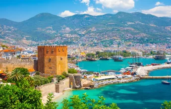
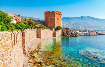
Alanya is 135 km from the city center within the borders of Antalya Province. away from the Mediterranean coast and covers an area of 175,658 hectares between 36°30’07” and 36°36’31” northern latitudes and 31°38’40” and 32°32’02” east longitudes. The height of the plateau section, which is located in the mountainous and plateau part of the extension, is around 1000 meters from the sea. Alanya peninsula, surrounded by 6500 meters long walls, is located in the south. The peninsula is separated from the Taurus Mountains by plains. It is possible to pass through the Dim and Alara valleys, which are named after Koçdovat Pass, Kuşyuvası, Yelköprü, Dim and Alara Streams, from the Taurus Mountains, which do not allow passage to the north from the sea. The fact that Alanya peninsula, which has a very steep profile from the coast, has a difficult connection with Central Anatolia and has a natural harbor in the east, has led to the development of sea transportation in the region over time. Transportation to Alanya from National and International centers, both by road and by air, is generally provided by road via Antalya.
Topographic Structure
The structure of the Kandeleri (Alanya) peninsula, which is 212 meters high from the sea, is one of the places where the smooth coastline in the east of the Antalya Bay has deteriorated, consists of permo crystalline limestones. The fractures found between crystalline limestones and schists while descending from this elevation to the plain are traces of young tectonic movements. The depression formed as a result of tectonic movements was covered with transported alluvium and formed the plain. Permo carbon crystalline limestones belonging to the Alanya massif, which is the continuation of the part of the Taurus Mountains on the north side of the city, are 1.5-2 km inland from the coast. they draw an arc in depth. This coastal plain of Alanya ends by widening in the Obçayı valley in the east. In the eastern part of the Obacai valley, there is the Dim stream valley, which is crossed with a threshold of 20-30 meters.
The north of the region, which is open to the Mediterranean from the south, is surrounded by forests. Antalya is of great importance in terms of underground riches. The most important mineral deposits identified but not operated in Alanya by the Mineral Research and Exploration Institute (MTA) are Aluminum (Bauxite), Barite, Phosphate, Quartzite and Emery.